
Table of Contents
- 1 Cliff Walk from Bray to Greystones
- 2 Important Update:
- 3 Bray to Greystones Route Information
- 4 How to get to Bray or Greystones
- 5 Where to start the Bray to Greystones walk?
- 6 ROUTE UPDATE:
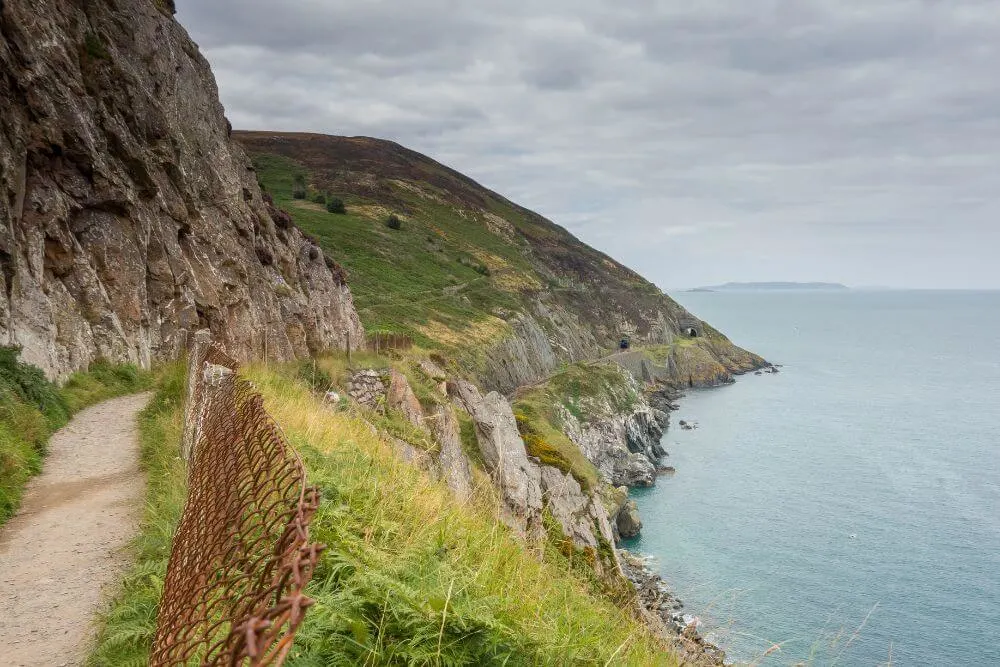
- 7 Bray Greystones Cliff Walk – Points of Interest
- 8 History of the Bray to Greystones Railway line
- 9 Bray Greystones Cliff Walk FAQs
- 10 Bray Greystones Walk Interesting Facts
- 11 Walking in Wicklow and Beyond
Cliff Walk from Bray to Greystones
County Wicklow is a great destination for walkers, with superb places to explore and discover. Of all the walks that Wicklow has to offer, the Cliff Walk from Bray to Greystones is a highlight for many people.
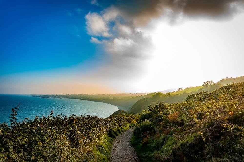
This linear walk connects the coastal towns of Bray and Greystones in County Wicklow and offers spectacular views of the Dublin Mountains, Killiney Hill, Dalkey, Howth and the Irish Sea.
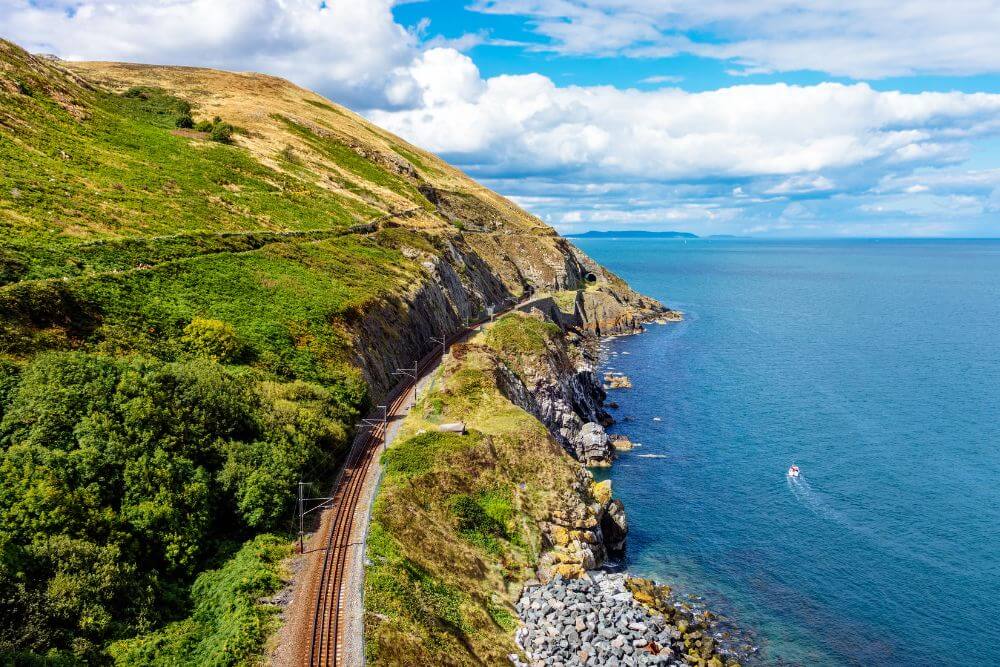
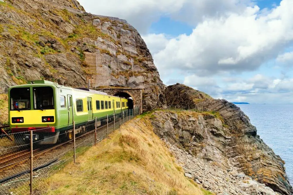
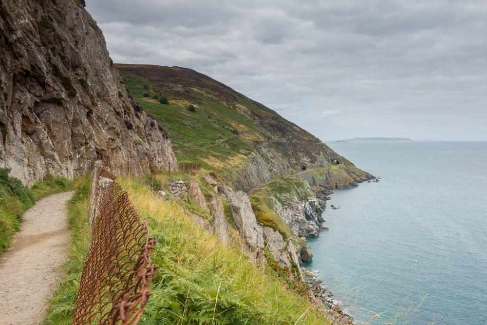
The path was cut into the cliff face and originally functioned as a road for the workers during the construction of the railway in the 1840s. It skirts around the base of Bray Head and hugs the coastline above the railway tracks to the seaside town of Greystones.
This much loved, easily accessible coastal walk is a popular outing for both locals and those from further afield.
Another advantage of this cliff path walk is that the towns at either end are well worth checking out. Soak up some of the seaside atmosphere and sample the tasty food options in either Greystones and Bray to nicely finish off the trip.
Important Update:
In October 2022 there was a major rockfall on the route and the entire walk is currently completely closed to the public.
Please check with the local media for the latest updates.
Bray to Greystones Route Information
Key Highlights of the Cliff Walk Bray to Greystones
- Panoramic views of the Irish Sea and east coast of Ireland from Howth Head down the Wicklow Coast
- Possibilities to see Common Lizards, Cormorants, Kestrels, Falcons, Kittiwakes, Black Harbor Porpoises, Bottlenose Dolphins and even Basking Sharks
- Train spotting on the train tracks below the walk way
- Spectacular views of Bray town
- Ruins of the Lord Meath’s Lodge House
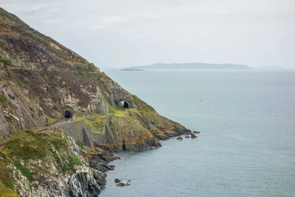
- View of railway tunnels (and former caves used for smuggling)
- Cable Rock and the Éire sign
- Finish up on Greystones Beach and head in for a swim!
Difficulty
The Bray to Greystones cliff walk is described as easy and suitable for people of most fitness levels.
There are some steps along the route so the Cliff Walk Bray to Greystones is not suitable for children in buggies or wheelchair users.
Length
Starting from the Bandstand on Bray Promenade to the end of the walk in Greystones Habour Marina, the cliff walk route covers about 7 km (4 miles).
Duration
The entire route of about 7km (4 miles) takes on average between 1.5 to 2.5 hours to complete, depending on your pace. There are plenty of scenic viewing points along the way and good opportunities to see wildlife, so it is best to take your time and not overly rush the experience.
Terrain
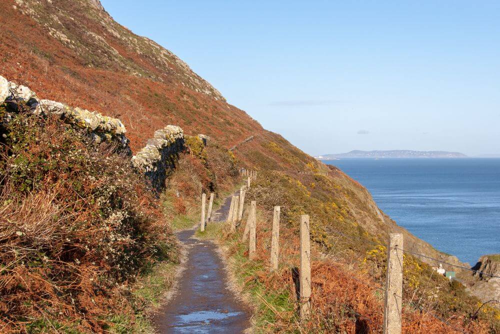
The coastal trail is a mix of mostly gravel with some unpaved and asphalt sections. There are also some steps along the route.
Equipment
Comfortable walking shoes or boots are advised for this walk..
After heavy rain, parts of the route can become partially flooded, so it is best to wear proper waterproof footwear for such conditions.
The weather can be changeable, especially being so close to the sea, so it is best to be prepared with a rain jacket, to keep off the wind and rain.
Other practical clothing, like hats or waterproofs may be necessary depending on the weather and time of year.
Tips for Bray to Greystones Walk Route:
Don’t forget to pack some water and some snacks for the route. Suncream can also (occasionally!) come in handy.
If you have a set of binoculars, then it is well worth bringing them along as well. The cliff walking route is a great place to spot some of Ireland’s native wildlife including the Common Lizards that might be sunning themselves on the stone of the pathway, seabirds, birds of prey, Bottlenose Dolphins, Black Harbor Porpoises or even the massive Basking Sharks that can be seen in the coastal waters.
Best Time of the Year to do the Walk
The beauty with this walk is that it can be done at any time of the year. If you want to catch it at its best, then from about April to October is probably the most enjoyable time to visit.

As it is a popular route, it can get quite busy. Start early in the morning if you want to avoid the crowds and enjoy it at one of its best times (due to the early morning light from the east).
During the summer season is the best time there is a chance of catching a glimpse of the enormous Basking Sharks from the cliff walk. These giants, which are actually the second largest fish in the world, are harmless to humans and feed in Irish waters during the summer months.
Is it better to walk Bray to Greystones or Greystones to Bray?
It is possible to walk the Cliff Walk route in either direction as there are good transport connections (and parking options) in both Bray and Greystones.
Walk from Bray to Greystones
Generally the Bray to Greystones route is more popular. One advantage of this direction is that at the end of the route you could add in a swim on the sandy south beach of Greystones if the weather conditions suit, followed up by some gourmet food. Greystones is well known for its culinary delights, including the very famous vegetarian Happy Pear Restaurant.
Walk from Greystones to Bray
Many people claim that the Greystones to Bray Cliff Walk option is the more scenic because the views are most impressive on the Bray side of the walk.
The Greystones to Bray Walk offers great views of Bray Head and the option to finish up in Bray town. This seaside beach resort was a particularly popular holiday destination up until the mid-20th century and still has a special charm. It is worth taking some time to wander the famous Bray Promenade and see some of the Victorian buildings.

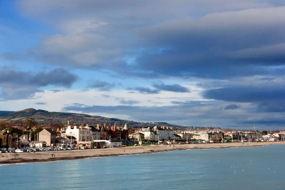
Don’t forget to have an ice cream from Teddy’s. This ice cream business, which originally opened in Dun Laoghaire, has been in business since the 1950s and is a must if you want to enjoy a local treat!
How to get to Bray or Greystones
There are good transport connections by rail and bus, as well as public parking facilities at either end of the cliff walk, so whether you decide to start in Bray and walk towards Greystones or the reverse is up to you.
Public Transport from Dublin to Bray

If you are using public transport, the more scenic, as well as direct route is to take the DART (Dublin train link), rather than use the Dublin Bus route 145 or 155.
Bray DART Times and Greystones DART Times can be found here.
The bus routes tend to take a while and you miss out on the railway trip. Close to Bray, the railway line follows the coast and it is something not to be missed!
The distance from Dublin to Bray is about 41 km or 25 miles (along the M50 motorway) and it takes roughly about 40 minutes to travel from the center of Dublin to Bray by car. However, this can vary quite a lot depending on traffic.
Bray to Greystones Walk Parking
There is a free car park in Bray just at the start of the walk (Raheen Park car park), but it is worth knowing that the Bray parking options can be limited at weekends or when the weather is good.
There are additional options for paid parking in Bray, such as along the Bray Promenade (just keep an eye out for the parking duration zones).
Where to start the Bray to Greystones walk?
If you are coming from Bray Railway Station, then head towards the shore and walk along the Bray Promenade in the direction of Bray Head.
Follow the road and signs and you will find the start of the Cliff Walk. (This is also where Raheen car park is located.)
ROUTE UPDATE:
PLEASE NOTE: The entire Bray to Greystones Walk is currently closed for safety reasons due to dangerous landslide in October 2022.
Alternative Routes Bray Walk Options – (Not available at present!)
It is not possible to walk the Alternative Route Options at the present time. Please check with the local media for the most recent updates.
Cliff Walk Return Route
It is possible to walk a section of the Bray to Greystones walkway (as far as the Windgate Steps) and then retrace your steps back along the same route back to Bray.
Some recommend the reverse route because of the scenic views of Bray Head, so it is well be worth checking out.
Bray Head Walk
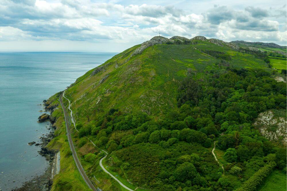

The other alternative is to take the more strenuous climb up to Bray Head.
Follow path up the Windgate Steps to connect with the Bray Head Walk. This walk is about 9.8 km in total (Difficulty: Challenging). It involves a tough climb, with steep sections on narrow paths with uneven ground lined brambles and furze bushes. Due to these conditions, it should only be attempted by people who are physically fit for the route.
This route offers impressive views over Bray, as well as the panorama of the Wicklow Mountains.
Bray Greystones Cliff Walk – Points of Interest

Naylor’s Cove
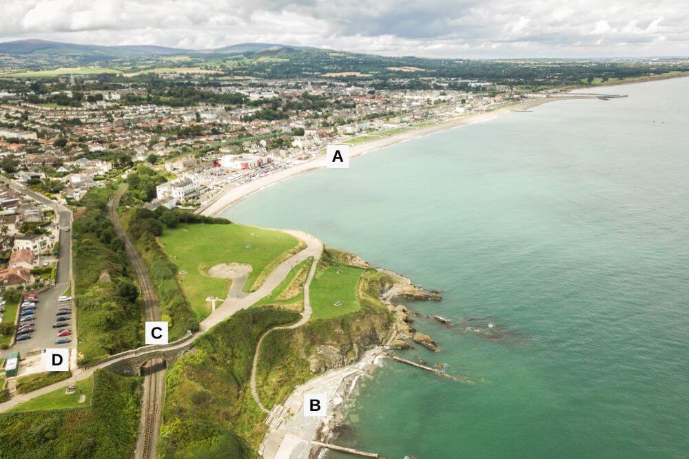
After walking along the Promenade and following the signs for the Cliff Walk, you will see the remains of the Old Bray Cove Baths in Naylors Cove.
This bathing and diving spot was extremely popular in its heyday, before it fell into disrepair and eventually dereliction in the 1970s. Many of the older generations of local people have very fond memories of this location as it was the site where many young children spent their summer holidays and learned to swim.
Fiddler’s Bridge
A little further along the road is “Fiddler’s Bridge”, which is roughly the spot where several fiddlers down through the years played their tune to entertain the visitors. One of the more unique fiddlers was the blind, native Irish speaker Pádraig Ó Grádaigh from West Cork.
Bray Chairlift
Raheen Car park comes up next. There is a concrete section in the carpark that many people use as a viewing point. What some people do not know is that it was once the base of the Bray Chairlift that brought people to the top of the Eagles Nest Restaurant and Ballroom and Bray Head. It operated between 1952 and 1970.
Along the route there is a bench with a wildlife mural pointing out all of the different animals that can be observed in the area. Try to spot some on the walk if you can!
Lord Meath’s Lodge and Toll Gate

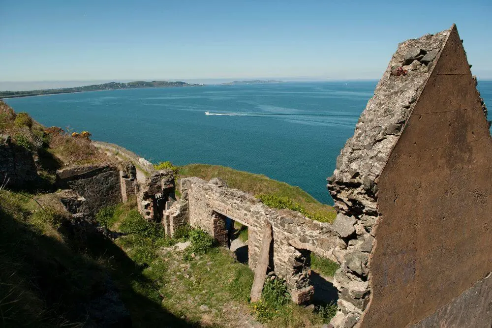
The ruins of Lord Meath’s Lodge are found along the pathway. Originally, this cottage marked the start of Lord Meath’s property and it is where a toll gate operated. Anyone who wished to walk the path had to pay the toll of one penny. The route was closed on Fridays for the exclusive use of Lord Meath and Brabazon Family.
The Brandy Hole Smuggling Spot
There is a spot on the route that is still called after the famous smuggling spot, the Brandy Hole. Its hidden location was perfect as it could not be easily observed by either the coastguard in Bray or in Greystones.
Although the cavern itself was destroyed when the railway had to be rerouted due to erosion in the 1850s, the name is still used. This famous cave was where illicit goods such as brandy, wines, gins, teas and silks often from France were transported at night into passages of the cave system to avoid detection from the Customs Officials.
Cable Rock
Another sight along the route is Cable Rock. The unusual name stems from the submerged rocks just beneath the water surface. Ships were required to leave the length of a cable (ca. 200 m or ) between the vessel and the rocks to avoid hitting these underwater obstacles.
Close to Cable Rock, the remains of an old “Eire” sign can be seen. This is one of many such signs that are still scattered around the Irish coastline and are remnants of World War II. These were used to tell the allied pilots that they had reached neutral Ireland.

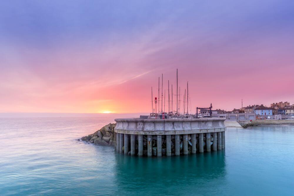
The remaining final section of the route has plenty of grassy verges and scenic views as the route enters Greystones Marina Park and onwards to Greystones Harbour Marina.
For those heading to the Greystones Dart Station, it is located a little further on the northern end of Greystones South Beach.
History of the Bray to Greystones Railway line

Initial plans to route the railway line across Lord Meath’s land were rejected as he did not want his land divided by the railway line. Instead he offered the coastal strip of land to be developed free of charge.
The famous engineer, Isambard Kingdom Brunel was responsible for its complex planning and design. The design of the route was very ambitious, but unfortunately due to the many complications and costly maintenance, it became known as “Brunel’s Folly”.
The option to build so close to the coast at this location was (and still continues to be) a costly decision one. The geology and exposed nature of the site caused complications and over the years the route has had to be diverted and realigned several times. Continued maintenance on this section of the line continues to be very costly.
There was a train derailment on the route on August 9th 1867, when a train fell from a viaduct near the Brandy Hole. This resulted in the deaths of two people and many injured passengers and because of the location, the rescue operation was very difficult.
After this incident a new tunnel was built in the cliff face. The remains of the old tunnel closer to the sea can still be seen.
Bray Greystones Cliff Walk FAQs
Is the Bray to Greystones Walk open?
At present it is not possible to walk the entire route from Bray to Greystones. This is due to dangerous landslides on the Greystones side of the route. While it is possible to walk a section of the route from Bray to Greystones, the Cliff walk Greystones to Bray should not be attempted at this time.
See the alternative routes suggested in the text above.
For the latest information, please check here.
What is the Bray to Greystones walk distance?
The cliff walk from Bray to Greystones is roughly about 7km or a little more than 4 miles. It is a suitable walk for people of average fitness, including families with older children.
Is it possible to do the Bray to Greystones walk with buggy?
No, the cliff walk is not advisable for buggy use as the route contains some steps and uneven ground. Sections of the route are narrow and rocky in places.
It is really only suitable for older children who can walk the route themselves.
Please note:
For safety reasons and in order to protect biodiversity, stay on the path and do not wander off it. This is a cliff walkway and the necessary level of precaution must be taken. Please follow the no trace rule while you enjoy this lovely walking route so that others can also do the same.
Bray Greystones Walk Interesting Facts
- A short distance from the Raheen Park car park is St. Patrick’s Well and the ruin of the medieval church of Raheen-A-Cluig (or Raheen na gClig). This small church was thought to be built sometime between the 12th and 13th century and renovated at a later date. Recent excavations at the site have shown evidence of a Neolithic or early Bronze Age tool production site and that the church was probably repurposed as a house sometime around the 17th century. It has many stories associated with it, including tales of smuggling and ghost stories.
- The oldest fossils in Ireland come from Bray Head and are called Oldhamia after their finder, Thomas Oldham. These trace fossils resemble the spokes on a bicycle wheel and show the burrow trails of worm-like organisms 540 million years ago.
- Ardmore Studios which has produced some well known films, such as Braveheart, My Left Foot and Veronica Guerin is located in Bray.
- Bray is also where Ireland’s biggest air show takes place. The Bray Air Display is a free event that takes place in the summer and attracts huge crowds. Spectators watch dizzying aerobic displays from the likes of the Red Arrows, the Irish Air Corps and the Royal Jordanian Falcons.
Walking in Wicklow and Beyond
For those interested in more walking options in Wicklow County, the Bray Head Loop Walk (5.5km or miles, Difficulty: Medium) or the De Buitléar Way (ca. 4 km or 2.5 miles) are two more options in the near vicinity. A map of these other routes can be found on the Bray tourism website.
The nearby Wicklow National Park offers several walking trails suitable for a range of different abilities.
Howth Cliff Walk is another scenic coastal route to the north of Dublin.
If you want to walk around the Capital City to find some unusual sights in Dublin, then this is a good post for you!